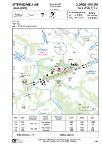


LFCO - Oloron Herrere
Located in Oloron, France
ICAO - LFCO, IATA -
Data provided by AirmateGeneral information
Coordinates: N43°9'53" W0°33'37"
Elevation is 984 feet MSL.
Magnetic variation is 0.46° East View others Airports in Aquitaine
Operational data
Special qualification required
Current time UTC:
Current local time:
Weather at : LFBP - Pau Pyrenees ( 27 km )
METAR: LFBP 280930Z AUTO 10004KT 020V180 CAVOK 15/08 Q1013 NOSIG
TAF: TAF LFBP 280500Z 2806/2906 VRB03KT 9999 SCT025 BKN040 TEMPO 2815/2824 -SHRA SCT035TCU PROB40 TEMPO 2815/2820 01010KT SHRA BKN020 SCT030CB
Communications frequencies: [VIEW]
Runways:
| RWY identifier | QFU | Length (ft) | Width (ft) | Surface | LDA (ft) |
| 07L | 71° | 3543 | 164 | GRASS | 3543 |
| 25R | 251° | 3543 | 164 | GRASS | 3117 |
| 07R | 71° | 3379 | 230 | GRASS | 2395 |
| 25L | 251° | 3379 | 230 | GRASS | 2953 |
Airport contact information
Address: Oloron France
Fuel provider

Other aviation service providers
Aviation club (not for profit)

Club Rsa Ass Contructeurs Amateurs Oloronais
Club Rsa Ass Contructeurs Amateurs Oloronais
constructeurs.amateurs@orange.fr0607575363
