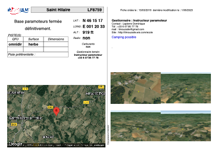


LF8759 - Saint Hilaire
Located in Saint-Hilaire-la-Treille, France
ICAO - , IATA -
Data provided by AirmateGeneral information
Coordinates: N46°15'17" E1°20'33"
Elevation is 919 feet MSL.
View others Airports in Centre
Operational data
Special qualification required
Current time UTC:
Current local time:
Weather at : LFBL - Limoges Bellegarde ( 46 km )
METAR: LFBL 271930Z AUTO 12006KT 090V220 9999 FEW005/// SCT015/// OVC086/// ///TCU 09/09 Q1001 BECMG BKN030
TAF: TAF AMD LFBL 271845Z 2718/2818 12010KT 9999 BKN030 TEMPO 2718/2720 15015G25KT 3000 SHRA BKN010 BKN020TCU BECMG 2722/2724 21010KT BKN010 TEMPO 2803/2806 2000 BR BKN002 BECMG 2808/2810 BKN020 PROB40 TEMPO 2814/2818 21015G25KT 4000 SHRA FEW015TCU BKN020
Communications frequencies: [VIEW]
Runways:
Airport contact information
Address: Saint-Hilaire-la-Treille France