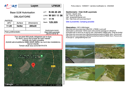


LF8528 - Luçon
Located in Luçon, France
ICAO - , IATA -
Data provided by AirmateGeneral information
Coordinates: N46°25'29" W1°11'36"
Elevation is 11 feet MSL.
View others Airports in Upper Normandy
Operational data
Special qualification required
Current time UTC:
Current local time:
Weather at : LFBH - La Rochelle Ile De Re ( 27 km )
METAR: LFBH 040200Z AUTO 12009KT 7000 -RA FEW008/// OVC027/// ///TCU 10/09 Q1012 BECMG 4500 -RA SCT015 BKN030
TAF: TAF LFBH 032300Z 0400/0424 15008KT 4500 -RA SCT015 BKN030 BECMG 0402/0404 09010KT TEMPO 0404/0408 2500 RADZ BKN005 OVC012 FM040800 23015G27KT 9999 BKN016 BECMG 0416/0418 22010KT TEMPO 0408/0420 4000 -RA BKN012 BKN020 TEMPO 0420/0424 BKN012
Communications frequencies: [VIEW]
Runways:
| RWY identifier | QFU | Length (ft) | Width (ft) | Surface | LDA (ft) |
| 11 | 0° | 918 | 65 | GRASS | |
| 29 | 0° | 918 | 65 | GRASS |
Airport contact information
Address: Luçon France