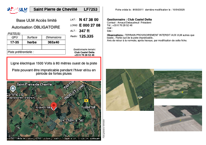


LF7253 - Saint Pierre de Chevillé
Located in Saint-Pierre-de-Chevillé, France
ICAO - , IATA -
Data provided by AirmateGeneral information
Coordinates: N47°37'60" E0°27'8"
Elevation is 347 feet MSL.
View others Airports in Centre
Operational data
Special qualification required
Current time UTC:
Current local time:
Weather at : LFOT - Tours Val De Loire ( 30 km )
METAR: LFOT 271500Z AUTO VRB03KT 9999 -RA BKN035/// BKN046/// BKN058/// ///CB 14/12 Q0998 TEMPO VRB15G30KT 2000 SHRA
TAF: TAF AMD LFOT 271336Z 2713/2812 19012KT 9999 BKN030 TEMPO 2713/2719 20015G25KT 3000 SHRA BKN020 BKN035TCU TEMPO 2713/2717 VRB15G30KT 2000 SHRA BKN020 BKN030CB PROB40 TEMPO 2713/2717 TSRA TEMPO 2800/2804 23015G25KT RA BKN010
Communications frequencies: [VIEW]
Runways:
| RWY identifier | QFU | Length (ft) | Width (ft) | Surface | LDA (ft) |
| 17 | 0° | 1197 | 131 | GRASS | |
| 35 | 0° | 1197 | 131 | GRASS |
Airport contact information
Address: Saint-Pierre-de-Chevillé France