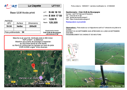


LF7151 - La Clayette
Located in Curbigny, France
ICAO - , IATA -
Data provided by AirmateGeneral information
Coordinates: N46°18'10" E4°17'50"
Elevation is 1230 feet MSL.
View others Airports in Burgundy
Operational data
Special qualification required
Current time UTC:
Current local time:
Weather at : LFLN - Saint Yan ( 24 km )
METAR: LFLN 291230Z AUTO 10006KT 9999 -RA FEW008/// SCT013/// OVC070/// //////TCU 13/11 Q1020 NOSIG
TAF: TAF LFLN 291100Z 2912/2921 09005KT 9999 FEW020 BKN070 TEMPO 2912/2921 -RA FEW030TCU
Communications frequencies: [VIEW]
Runways:
| RWY identifier | QFU | Length (ft) | Width (ft) | Surface | LDA (ft) |
| 16 | 0° | 656 | 65 | GRASS | |
| 34 | 0° | 656 | 65 | GRASS |
Airport contact information
Address: Curbigny France