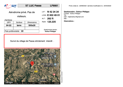


LF6661 - ST LUC Passa
Located in Passa, France
ICAO - , IATA -
Data provided by AirmateGeneral information
Coordinates: N42°34'34" E2°49'1"
Elevation is 262 feet MSL.
View others Airports in Languedoc-Roussillon
Operational data
Special qualification required
Current time UTC:
Current local time:
Weather at : LFMP - Perpignan Rivesaltes ( 19 km )
METAR: LFMP 032100Z AUTO 27002KT 9999 OVC072 15/07 Q1017 NOSIG
TAF: TAF LFMP 031400Z 0315/0415 12007KT 9999 SCT070 BECMG 0409/0411 07010KT
Communications frequencies: [VIEW]
Runways:
| RWY identifier | QFU | Length (ft) | Width (ft) | Surface | LDA (ft) |
| 04 | 0° | 1640 | 65 | DIRT | |
| 22 | 0° | 1640 | 65 | DIRT |
Airport contact information
Address: Passa France