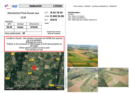


LF6530 - Sadournin
Located in Sadournin, France
ICAO - , IATA -
Data provided by AirmateGeneral information
Coordinates: N43°19'34" E0°25'0"
Elevation is 918 feet MSL.
View others Airports in Midi-Pyrénées
Operational data
Special qualification required
Current time UTC:
Current local time:
Weather at : LFBT - Tarbes Lourdes Pyrenees ( 37 km )
METAR: LFBT 280730Z AUTO 13005KT 9999 OVC041 10/06 Q1013 NOSIG
TAF: TAF LFBT 280500Z 2806/2906 VRB03KT 9999 SCT020 BKN035 TEMPO 2811/2816 03010KT TEMPO 2815/2822 -SHRA BKN020 SCT030CB TEMPO 2822/2906 -RA BKN013 SCT020TCU OVC030 PROB30 TEMPO 2822/2906 4000 RA BKN007
Communications frequencies: [VIEW]
Runways:
| RWY identifier | QFU | Length (ft) | Width (ft) | Surface | LDA (ft) |
| 08 | 0° | 2198 | 164 | GRASS | |
| 26 | 0° | 2198 | 164 | GRASS |
Airport contact information
Address: Sadournin France