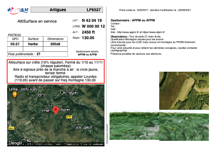


LF6527 - Artigues
Located in Artigues, France
ICAO - , IATA -
Data provided by AirmateGeneral information
Coordinates: N43°4'19" W0°0'12"
Elevation is 2450 feet MSL.
View others Airports in Midi-Pyrénées
Operational data
Special qualification required
Current time UTC:
Current local time:
Weather at : LFBT - Tarbes Lourdes Pyrenees ( 13 km )
METAR: LFBT 271430Z AUTO 20007KT 140V230 6000 RA FEW049/// OVC058/// ///CB 13/11 Q0999 TEMPO 29017G33KT 2000 TSRA
TAF: TAF LFBT 271100Z 2712/2812 17010KT CAVOK TEMPO 2712/2718 4000 SHRA SCT040CB BKN060 PROB30 TEMPO 2712/2717 29017G33KT 2000 TSRA BKN035CB BECMG 2716/2718 28008KT PROB30 TEMPO 2718/2722 BKN010 BECMG 2721/2723 VRB03KT BECMG 2810/2812 04007KT SCT035 BKN040
Communications frequencies: [VIEW]
Runways:
| RWY identifier | QFU | Length (ft) | Width (ft) | Surface | LDA (ft) |
| 03 | 0° | 656 | 26 | GRASS | |
| 21 | 0° | 656 | 26 | GRASS |
Airport contact information
Address: Artigues France