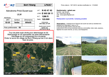


LF6357 - Bort l'Etang
Located in Bort-l'Etang, France
ICAO - , IATA -
Data provided by AirmateGeneral information
Coordinates: N45°47'43" E3°26'11"
Elevation is 1286 feet MSL.
View others Airports in Auvergne
Operational data
Special qualification required
Current time UTC:
Current local time:
Weather at : LFLC - Clermont Ferrand Auvergne ( 21 km )
METAR: LFLC 040530Z AUTO VRB01KT 9999 -DZ OVC045 08/06 Q1013 TEMPO 18015G25KT
TAF: TAF LFLC 040500Z 0406/0506 19008KT 9999 BKN055 TEMPO 0406/0506 -RA PROB40 TEMPO 0407/0416 18015G25KT
Communications frequencies: [VIEW]
Runways:
| RWY identifier | QFU | Length (ft) | Width (ft) | Surface | LDA (ft) |
| 02 | 0° | 2624 | 180 | GRASS | |
| 20 | 0° | 2624 | 180 | GRASS |
Airport contact information
Address: Bort-l'Etang France