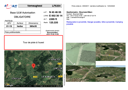


LF6354 - Verneugheol
Located in Verneugheol, France
ICAO - , IATA -
Data provided by AirmateGeneral information
Coordinates: N45°46'5" E2°30'14"
Elevation is 2395 feet MSL.
View others Airports in Limousin
Operational data
Special qualification required
Current time UTC:
Current local time:
Weather at : LFLC - Clermont Ferrand Auvergne ( 51 km )
METAR: LFLC 021830Z AUTO 29006KT 260V320 9999 FEW062 BKN072 BKN098 11/06 Q1012 TEMPO 3000 SHRA BKN030TCU
TAF: TAF LFLC 021700Z 0218/0318 28008KT 9999 BKN035 PROB30 TEMPO 0218/0221 3000 SHRA BKN030TCU BECMG 0221/0223 22006KT CAVOK BECMG 0308/0310 SCT035TCU BKN040 PROB40 TEMPO 0310/0318 4000 SHRA BKN035TCU PROB30 TEMPO 0312/0318 VRB15KT 2000 TSRA BKN030CB
Communications frequencies: [VIEW]
Runways:
| RWY identifier | QFU | Length (ft) | Width (ft) | Surface | LDA (ft) |
| 01 | 0° | 1246 | 114 | GRASS | |
| 19 | 0° | 1246 | 114 | GRASS |
Airport contact information
Address: Verneugheol France