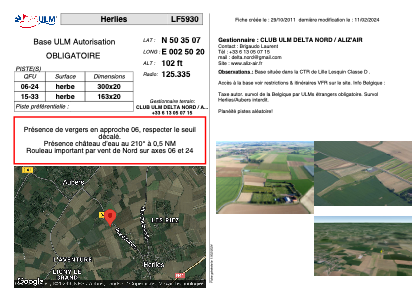


LF5930 - Herlies
Located in Herlies, France
ICAO - , IATA -
Data provided by AirmateGeneral information
Coordinates: N50°35'7" E2°50'20"
Elevation is 102 feet MSL.
View others Airports in Nord-Pas-de-Calais
Operational data
Special qualification required
Current time UTC:
Current local time:
Weather at : LFQQ - Lille Lesquin ( 18 km )
METAR: LFQQ 271000Z AUTO 15010KT 120V180 9999 BKN019 BKN028 BKN034 14/10 Q1003 NOSIG
TAF: TAF LFQQ 270500Z 2706/2812 14006KT 6000 SCT030 TEMPO 2706/2708 2000 BR BKN002 TEMPO 2708/2710 BKN006 PROB40 TEMPO 2712/2716 VRB15G25KT 3000 SHRA SCT013 BKN020CB TEMPO 2716/2722 VRB15G25KT 3000 RA SCT008 BKN013 BKN020CB PROB30 TEMPO 2716/2720 1000 TSRA BECMG 2803/2806 18015G25KT TEMPO 2806/2812 18020G35KT 4000 SHRA BKN013
Communications frequencies: [VIEW]
Runways:
| RWY identifier | QFU | Length (ft) | Width (ft) | Surface | LDA (ft) |
| 08 | 0° | 1017 | 82 | GRASS | |
| 26 | 0° | 1017 | 82 | GRASS |
Airport contact information
Address: Herlies France
Web: www.delta-nord.org