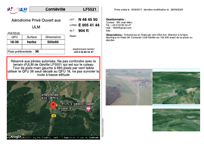


LF5521 - Corniéville
Located in Géville, France
ICAO - , IATA -
Data provided by AirmateGeneral information
Coordinates: N48°45'50" E5°41'44"
Elevation is 904 feet MSL.
View others Airports in Lorraine
Operational data
Special qualification required
Current time UTC:
Current local time:
Weather at : LFSO - Nancy Ochey ( 28 km )
METAR: LFSO 032130Z AUTO 16007KT CAVOK 09/05 Q1016
Communications frequencies: [VIEW]
Runways:
| RWY identifier | QFU | Length (ft) | Width (ft) | Surface | LDA (ft) |
| 18 | 0° | 1640 | 196 | GRASS | |
| 36 | 0° | 1640 | 196 | GRASS |
Airport contact information
Address: Géville France