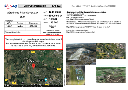


LF5422 - Villerupt Micheville
Located in Villerupt, France
ICAO - , IATA -
Data provided by AirmateGeneral information
Coordinates: N49°29'7" E5°55'4"
Elevation is 1305 feet MSL.
View others Airports in Lorraine
Operational data
Special qualification required
Current time UTC:
Current local time:
Weather at : ELLX - Luxembourg ( 26 km )
METAR: ELLX 031620Z 24010KT 9999 FEW040 14/05 Q1014 NOSIG
TAF: TAF ELLX 031100Z 0312/0418 24012KT 9999 BKN025 PROB30 TEMPO 0312/0316 22015G25KT SCT023TCU BECMG 0318/0321 16007KT TEMPO 0411/0418 SCT025TCU
Communications frequencies: [VIEW]
Runways:
| RWY identifier | QFU | Length (ft) | Width (ft) | Surface | LDA (ft) |
| 14 | 0° | 2624 | 164 | GRASS | |
| 32 | 0° | 2624 | 164 | GRASS |
Airport contact information
Address: Villerupt France