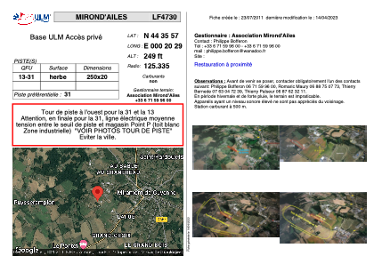


LF4730 - MIROND'AILES
Located in Miramont-de-Guyenne, France
ICAO - , IATA -
Data provided by AirmateGeneral information
Coordinates: N44°35'57" E0°20'29"
Elevation is 249 feet MSL.
View others Airports in Aquitaine
Operational data
Special qualification required
Current time UTC:
Current local time:
Weather at : LFBE - Bergerac Dordogne Perigord ( 29 km )
METAR: LFBE 280930Z AUTO VRB03KT 9999 FEW019 SCT024 15/09 Q1013 BECMG FEW025TCU SCT030
TAF: TAF LFBE 280500Z 2806/2906 15005KT 9999 SCT030 BECMG 2810/2812 21010KT FEW025TCU SCT030 PROB40 TEMPO 2814/2818 4000 SHRA FEW025TCU BKN030 BECMG 2814/2816 32005KT BECMG 2819/2821 CAVOK PROB30 TEMPO 2903/2906 4000 BR
Communications frequencies: [VIEW]
Runways:
| RWY identifier | QFU | Length (ft) | Width (ft) | Surface | LDA (ft) |
| 13 | 0° | 820 | 65 | GRASS | |
| 31 | 0° | 820 | 65 | GRASS |
Airport contact information
Address: Miramont-de-Guyenne France