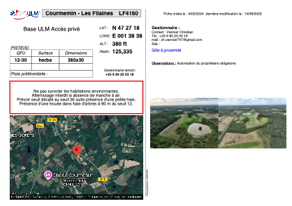


LF4160 - Courmemin - Les Filaines
Located in Courmemin, France
ICAO - , IATA -
Data provided by AirmateGeneral information
Coordinates: N47°27'18" E1°38'38"
Elevation is 380 feet MSL.
View others Airports in Centre
Operational data
Special qualification required
Current time UTC:
Current local time:
Weather at : LFYR - Romorantin Pruniers ( 15 km )
METAR: LFYR 302130Z AUTO 26002KT CAVOK 11/10 Q1015
TAF: TAF LFYR 301400Z 3015/3115 27008KT 9999 SCT025 TEMPO 3015/3020 4000 SHRA BKN030CB PROB40 TEMPO 3015/3018 28015G35KT 2000 TSRA BKN020CB BECMG 3102/3104 BKN010 BECMG 3108/3110 BKN020 TEMPO 3112/3115 4000 SHRA BKN030CB
Communications frequencies: [VIEW]
Runways:
| RWY identifier | QFU | Length (ft) | Width (ft) | Surface | LDA (ft) |
| 12 | 0° | 1246 | 98 | GRASS | |
| 30 | 0° | 1246 | 98 | GRASS |
Airport contact information
Address: Courmemin France