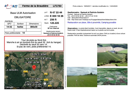


LF3760 - Ferme de la Braudière
Located in Villiers-au-Bouin, France
ICAO - , IATA -
Data provided by AirmateGeneral information
Coordinates: N47°33'44" E0°18'26"
Elevation is 256 feet MSL.
View others Airports in Centre
Operational data
Special qualification required
Current time UTC:
Current local time:
Weather at : LFOT - Tours Val De Loire ( 34 km )
METAR: LFOT 272330Z AUTO 17008KT 9999 OVC008 10/09 Q1001 TEMPO BKN008 FEW030TCU
TAF: TAF LFOT 272300Z 2800/2824 19012KT 9999 FEW010 BKN020 TEMPO 2800/2805 22013G25KT -SHRA BKN008 FEW030TCU TEMPO 2812/2818 -SHRA FEW030TCU BKN040 PROB30 TEMPO 2813/2816 26015G25KT 4000 SHRA SCT025CB BECMG 2818/2821 13004KT
Communications frequencies: [VIEW]
Runways:
| RWY identifier | QFU | Length (ft) | Width (ft) | Surface | LDA (ft) |
| 14 | 0° | 1246 | 98 | GRASS | |
| 32 | 0° | 1246 | 98 | GRASS |
Airport contact information
Address: Villiers-au-Bouin France