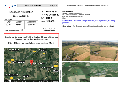


LF3552 - Amanlis Janzé
Located in Amanlis, France
ICAO - , IATA -
Data provided by AirmateGeneral information
Coordinates: N47°59'35" W1°29'29"
Elevation is 203 feet MSL.
Magnetic variation is 0° East View others Airports in Brittany
Operational data
Special qualification required
Current time UTC:
Current local time:
Weather at : LFRN - Rennes Saint Jacques ( 20 km )
METAR: LFRN 291630Z AUTO 22010KT 9999 FEW048 BKN058 16/06 Q1016 NOSIG
TAF: TAF LFRN 291100Z 2912/3012 21010KT 9999 SCT040 BECMG 2920/2922 14005KT TEMPO 3002/3007 3000 BR PROB40 TEMPO 3003/3006 0500 FG BECMG 3010/3012 20013KT
Communications frequencies: [VIEW]
Runways:
| RWY identifier | QFU | Length (ft) | Width (ft) | Surface | LDA (ft) |
| 09 | 0° | 1148 | 131 | GRASS | |
| 27 | 0° | 1148 | 131 | GRASS |
Airport contact information
Address: Amanlis France