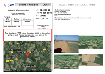


LF3531 - Moulins le Haut Bois
Located in Moulins, France
ICAO - , IATA -
Data provided by AirmateGeneral information
Coordinates: N48°0'6" W1°21'8"
Elevation is 200 feet MSL.
View others Airports in Brittany
Operational data
Special qualification required
Current time UTC:
Current local time:
Weather at : LFRN - Rennes Saint Jacques ( 29 km )
TAF: TAF LFRN 291100Z 2912/3012 21010KT 9999 SCT040 BECMG 2920/2922 14005KT TEMPO 3002/3007 3000 BR PROB40 TEMPO 3003/3006 0500 FG BECMG 3010/3012 20013KT
Communications frequencies: [VIEW]
Runways:
| RWY identifier | QFU | Length (ft) | Width (ft) | Surface | LDA (ft) |
| 18 | 0° | 820 | 164 | GRASS | |
| 36 | 0° | 820 | 164 | GRASS |
Airport contact information
Address: Moulins France