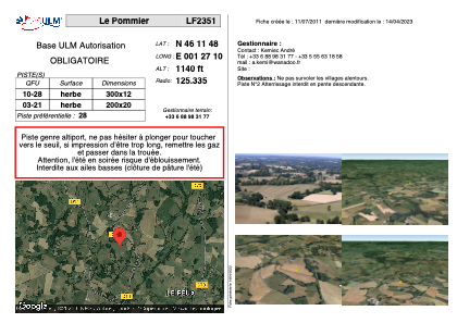


LF2351 - Le Pommier
Located in Saint-Maurice-la-Souterraine, France
ICAO - , IATA -
Data provided by AirmateGeneral information
Coordinates: N46°11'48" E1°27'10"
Elevation is 1140 feet MSL.
View others Airports in Centre
Operational data
Special qualification required
Current time UTC:
Current local time:
Weather at : LFBL - Limoges Bellegarde ( 43 km )
METAR: LFBL 210030Z AUTO 10005KT CAVOK 15/11 Q1017 NOSIG
TAF: TAF LFBL 202300Z 2100/2124 09005KT CAVOK BECMG 2107/2109 15010KT TEMPO 2115/2124 4000 SHRA BKN040TCU
Communications frequencies: [VIEW]
Runways:
| RWY identifier | QFU | Length (ft) | Width (ft) | Surface | LDA (ft) |
| 10 | 0° | 984 | 39 | GRASS | |
| 28 | 0° | 984 | 39 | GRASS |
Airport contact information
Address: Saint-Maurice-la-Souterraine France