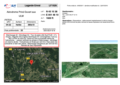


LF1926 - Lagarde Enval
Located in Lagarde-Enval, France
ICAO - , IATA -
Data provided by AirmateGeneral information
Coordinates: N45°10'38" E1°48'10"
Elevation is 1600 feet MSL.
View others Airports in Limousin
Operational data
Special qualification required
Current time UTC:
Current local time:
Weather at : LFSL - Brive Souillac ( 29 km )
METAR: LFSL 030100Z AUTO 00000KT CAVOK 04/03 Q1017
TAF: TAF LFSL 021400Z 0215/0224 32005KT 9999 BKN035 TEMPO 0215/0217 28015G25KT 4000 SHRA BKN010 BKN020TCU
Communications frequencies: [VIEW]
Runways:
| RWY identifier | QFU | Length (ft) | Width (ft) | Surface | LDA (ft) |
| 04 | 0° | 1246 | 32 | GRASS | |
| 22 | 0° | 1246 | 32 | GRASS |
Airport contact information
Address: Lagarde-Enval France