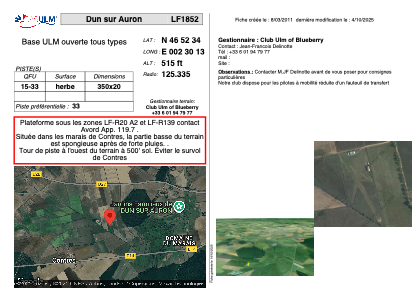


LF1852 - Dun sur Auron
Located in Dun-sur-Auron, France
ICAO - , IATA -
Data provided by AirmateGeneral information
Coordinates: N46°52'34" E2°30'13"
Elevation is 515 feet MSL.
View others Airports in Centre
Operational data
Special qualification required
Current time UTC:
Current local time:
Weather at : LFOA - Avord ( 23 km )
METAR: LFOA 281330Z AUTO 29005KT 240V360 9999 SCT048 BKN060 BKN070 17/07 Q1014
TAF: TAF LFOA 280800Z 2809/2909 23010KT 9999 BKN020 TX17/2816Z TN07/2905Z TEMPO 2813/2818 4000 SHRA BKN040TCU TEMPO 2901/2909 VRB02KT 3000 BR BKN002 PROB40 TEMPO 2903/2906 VRB02KT 0500 FG VV///
Communications frequencies: [VIEW]
Runways:
| RWY identifier | QFU | Length (ft) | Width (ft) | Surface | LDA (ft) |
| 15 | 0° | 1148 | 65 | GRASS | |
| 33 | 0° | 1148 | 65 | GRASS |
Airport contact information
Address: Dun-sur-Auron France