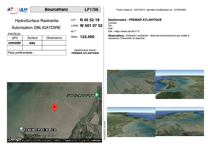


LF1756 - Bourcefranc
Located in Bourcefranc, France
ICAO - , IATA -
Data provided by AirmateGeneral information
Coordinates: N45°52'19" W1°7'52"
Elevation is feet MSL.
View others Airports in Poitou-Charentes
Operational data
Special qualification required
Current time UTC:
Current local time:
Weather at : LFBH - La Rochelle Ile De Re ( 34 km )
METAR: LFBH 291830Z AUTO 32005KT CAVOK 14/09 Q1017 NOSIG
TAF: TAF LFBH 291700Z 2918/3018 28008KT CAVOK
Communications frequencies: [VIEW]
Runways:
Airport contact information
Address: Bourcefranc France