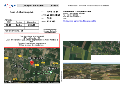


LF1755 - Courçon Eol'Aunis
Located in Courçon d'Aunis, France
ICAO - , IATA -
Data provided by AirmateGeneral information
Coordinates: N46°14'54" W0°49'51"
Elevation is 39 feet MSL.
View others Airports in Pays-de-la-Loire
Operational data
Special qualification required
Current time UTC:
Current local time:
Weather at : LFBH - La Rochelle Ile De Re ( 29 km )
METAR: LFBH 070030Z AUTO 29011KT 9999 SCT009 BKN036 OVC084 14/12 Q1015 TEMPO 4000 -RA BKN008
TAF: TAF LFBH 062300Z 0700/0724 30011KT CAVOK BECMG 0702/0705 BKN011 TEMPO 0702/0709 4000 -RA BKN008 BECMG 0708/0710 01008KT SCT020 BKN035 BECMG 0711/0713 30014KT PROB30 TEMPO 0713/0717 4500 -SHRA BKN025TCU
Communications frequencies: [VIEW]
Runways:
| RWY identifier | QFU | Length (ft) | Width (ft) | Surface | LDA (ft) |
| 10 | 0° | 951 | 65 | GRASS | |
| 28 | 0° | 951 | 65 | GRASS |
Airport contact information
Address: Courçon d'Aunis France