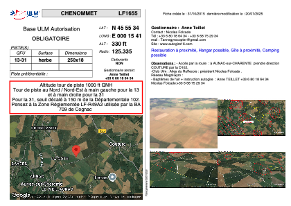


LF1655 - CHENOMMET
Located in Chenommet/Aunac-sur-Charente, France
ICAO - , IATA -
Data provided by AirmateGeneral information
Coordinates: N45°55'34" E0°15'41"
Elevation is 330 feet MSL.
View others Airports in Poitou-Charentes
Operational data
Special qualification required
Current time UTC:
Current local time:
Communications frequencies: [VIEW]
Runways:
| RWY identifier | QFU | Length (ft) | Width (ft) | Surface | LDA (ft) |
| 13 | 0° | 820 | 59 | GRASS | |
| 31 | 0° | 820 | 59 | GRASS |
Airport contact information
Address: Chenommet/Aunac-sur-Charente France
Web: www.autogire16.com