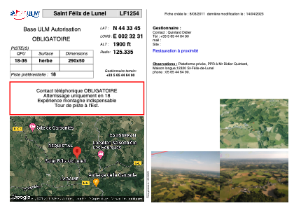


LF1254 - Saint Félix de Lunel
Located in Saint-Félix-de-Lunel, France
ICAO - , IATA -
Data provided by AirmateGeneral information
Coordinates: N44°33'45" E2°32'31"
Elevation is 1900 feet MSL.
View others Airports in Midi-Pyrénées
Operational data
Special qualification required
Current time UTC:
Current local time:
Weather at : LFCR - Rodez Aveyron ( 18 km )
METAR: LFCR 281430Z AUTO 35004KT 300V040 9999 OVC028 12/08 Q1015 NOSIG
TAF: TAF AMD LFCR 281106Z 2811/2906 VRB03KT 9999 SCT018 BKN030 TEMPO 2811/2813 BKN013 TEMPO 2900/2906 -RA BKN013 SCT020TCU OVC030 PROB30 TEMPO 2900/2906 4000 RA BKN007
Communications frequencies: [VIEW]
Runways:
| RWY identifier | QFU | Length (ft) | Width (ft) | Surface | LDA (ft) |
| 18 | 0° | 951 | 164 | GRASS | |
| 36 | 0° | 951 | 164 | GRASS |
Airport contact information
Address: Saint-Félix-de-Lunel France