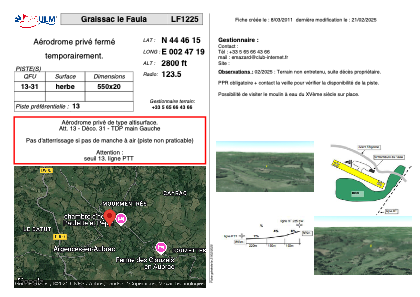


LF1225 - Graissac le Faula
Located in Ste-Geneviève-sur-Argence, France
ICAO - , IATA -
Data provided by AirmateGeneral information
Coordinates: N44°46'15" E2°47'19"
Elevation is 2800 feet MSL.
View others Airports in Auvergne
Operational data
Special qualification required
Current time UTC:
Current local time:
Weather at : LFLW - Aurillac ( 33 km )
METAR: LFLW 041000Z AUTO 20004KT 150V250 9999 OVC025/// //////TCU 12/08 Q1015 TEMPO 3000 RADZ BR BKN005 OVC012
TAF: TAF LFLW 040800Z 0409/0418 17010KT 9999 -RA BKN017 OVC025 TEMPO 0409/0412 3000 RADZ BR BKN005 OVC012 PROB40 TEMPO 0412/0415 4000 RA BKN012 TEMPO 0415/0418 3000 RA BKN008 SCT012TCU BKN015
Communications frequencies: [VIEW]
Runways:
| RWY identifier | QFU | Length (ft) | Width (ft) | Surface | LDA (ft) |
| 13 | 0° | 1804 | 65 | GRASS | |
| 31 | 0° | 1804 | 65 | GRASS |
Airport contact information
Address: Ste-Geneviève-sur-Argence France