


LETG - Aerodromo De Algodor (Toledo)
Located in Toledo, Spain
ICAO - , IATA -
Data provided by AirmateGeneral information
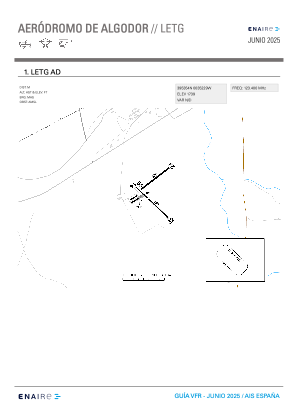
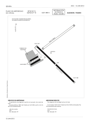
Coordinates: N39°53'53" W3°52'28"
Elevation is 1602 feet MSL.
Magnetic variation is 0° East View others Airports in Castilla-La Mancha
Operational data
Special qualification required
Current time UTC:
Current local time:
Weather at : LEGT - Madrid/Getafe ( 46 km )
METAR: LEGT 271130Z 21016KT 9999 SCT039 BKN048 13/05 Q1002
TAF: TAF LEGT 271100Z 2712/2812 23015KT 9999 FEW025 SCT035 TX16/2812Z TN05/2806Z PROB40 TEMPO 2712/2717 23020G30KT PROB40 TEMPO 2713/2719 4000 RA SHRA SCT030TCU SCT035CB PROB30 TEMPO 2713/2717 3000 TSRA BKN010 SCT035CB BECMG 2800/2802 24005KT PROB30 TEMPO 2806/2808 BKN006
Communications frequencies: [VIEW]
Runways:
| RWY identifier | QFU | Length (ft) | Width (ft) | Surface | LDA (ft) |
| 14 | 134° | 1334 | 41 | ASPH | |
| 28 | 0° | 1404 | 66 | ASPH | |
| 31 | 314° | 1334 | 41 | ASPH |
Airport contact information
Address: Toledo Spain
