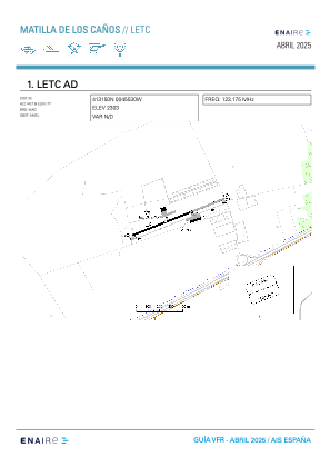


LETC - Matilla De Los Canos
Located in Matilla De Los Canos (Valladolid), Spain
ICAO - LETC, IATA -
Data provided by AirmateGeneral information
Coordinates: N41°31'51" W4°55'25"
Elevation is 2303 feet MSL.
Magnetic variation is 0° East View others Airports in Valladolid
Operational data
Special qualification required
Current time UTC:
Current local time:
Weather at : LEVD - Valladolid/Villanubla ( 20 km )
METAR: LEVD 081700Z 07007KT 040V100 CAVOK 21/04 Q1021
TAF: TAF LEVD 081400Z 0815/0915 05007KT CAVOK TX22/0816Z TN05/0905Z BECMG 0908/0910 VRB04KT
Communications frequencies: [VIEW]
Runways:
| RWY identifier | QFU | Length (ft) | Width (ft) | Surface | LDA (ft) |
| 07 | 68° | 1752 | 58 | ASPH | 1755 |
| 25 | 248° | 1752 | 58 | ASPH | 1755 |
Airport contact information
Address: Matilla De Los Canos (Valladolid) Spain