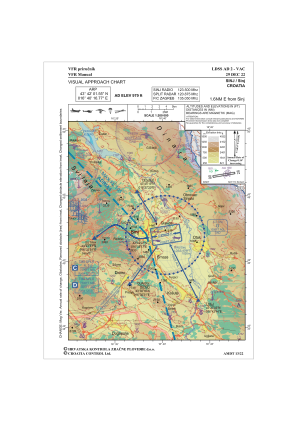
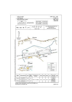


LDSS - Sinj
Located in Sinj, Croatia
ICAO - LDSS, IATA -
Data provided by AirmateGeneral information
Coordinates: N43°42'2" E16°40'17"
Elevation is 979 feet MSL.
Magnetic variation is 5° East View others Airports in Split-Dalmatia
Operational data
Special qualification required
Current time UTC:
Current local time:
Weather at : LDSP - Split / Kastela ( 35 km )
METAR: LDSP 022130Z 31003KT 9999 FEW028 SCT075 15/14 Q1010 NOSIG
TAF: TAF LDSP 021725Z 0218/0318 17008KT 9999 SCT030 TX18/0312Z TN12/0303Z PROB40 TEMPO 0218/0303 27015KT 4000 TSRA FEW020CB BKN027 BECMG 0309/0311 23010KT BECMG 0316/0318 31005KT
Communications frequencies: [VIEW]
Runways:
| RWY identifier | QFU | Length (ft) | Width (ft) | Surface | LDA (ft) |
| 08 | 81° | 3362 | 189 | GRAS | 3366 |
| 26 | 261° | 3362 | 189 | GRAS | 3366 |
Airport contact information
Address: Sinj Croatia
Web: www.aeroklubsinj.hr
