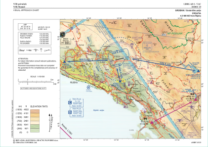
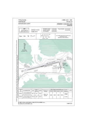


LDRG - Grobnik / Grobnicko Polje
Located in Rijeka, Croatia
ICAO - LDRG, IATA -
Data provided by AirmateGeneral information
Coordinates: N45°22'46" E14°30'13"
Elevation is 1012 feet MSL.
Magnetic variation is +004° East View others Airports in Primorje-Gorski Kotar
Operational data
Special qualification required
Current time UTC:
Current local time:
Weather at : LDRI - Rijeka / Krk I ( 19 km )
METAR: LDRI 290730Z VRB03KT CAVOK 19/11 Q1020
TAF: TAF LDRI 290525Z 2906/3006 VRB02KT CAVOK TX25/2913Z TN12/3004Z TEMPO 2910/2914 30007KT
Communications frequencies: [VIEW]
Runways:
| RWY identifier | QFU | Length (ft) | Width (ft) | Surface | LDA (ft) |
| 07 | 75° | 5185 | 96 | ASPH | 5243 |
| 25 | 255° | 5185 | 96 | ASPH | 5243 |
Airport contact information
Address: Rijeka Croatia