


L92 - Alamo Landing Fld
Located in Alamo, United States
ICAO - L92, IATA -
Data provided by AirmateGeneral information
Coordinates: N37°21'48" W115°11'44"
Elevation is 3757 feet MSL.
Magnetic variation is 14° East View others Airports in Nevada
Operational data
Special qualification required
Current time UTC:
Current local time:
Weather at : - ( 0 km )
METAR: CYAY 021913Z AUTO 01025G33KT 5SM -RA BR OVC005 02/02 A3011 RMK SLP199
Communications frequencies: [VIEW]
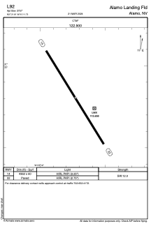
Runways:
| RWY identifier | QFU | Length (ft) | Width (ft) | Surface | LDA (ft) |
| 14 | 148° | 4362 | 60 | ASPH | |
| 32 | 328° | 4362 | 60 | ASPH |
Airport contact information
Address: Alamo United States