


KWRB - Robins Afb
Located in Warner Robins, United States
ICAO - WRB, IATA - WRB
Data provided by AirmateGeneral information
Coordinates: N32°38'25" W83°35'31"
Elevation is 294 feet MSL.
Magnetic variation is -02° East View others Airports in Georgia
Operational data
Special qualification required
Current time UTC:
Current local time:
Weather
METAR: KWRB 022155Z AUTO 08006KT 10SM CLR 32/13 A2993 RMK AO2 SLP135 T03190131
TAF: TAF KWRB 021600Z 0216/0322 VRB06KT 9999 SCT050 SCT200 QNH2998INS BECMG 0308/0309 VRB06KT 8000 BR SCT008 QNH2997INS BECMG 0311/0312 VRB06KT 9999 NSW SCT025 QNH3000INS BECMG 0316/0317 17009KT 9000 -SHRA BKN030 QNH2994INS TX32/0220Z TN17/0311Z
Communications frequencies: [VIEW]
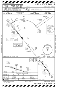
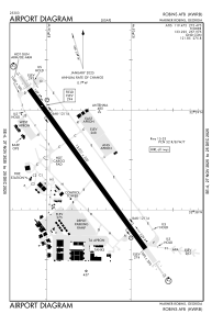
Runways:
| RWY identifier | QFU | Length (ft) | Width (ft) | Surface | LDA (ft) |
| 15 | 144° | 12001 | 300 | OTHER | |
| 33 | 324° | 12001 | 300 | OTHER |
Airport contact information
Address: Warner Robins United States