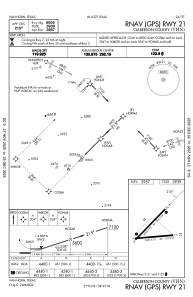
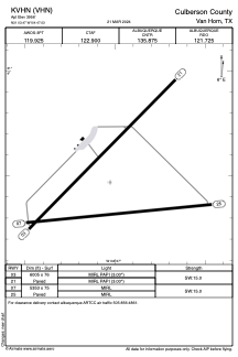


KVHN - Culberson County
Located in Van Horn, United States
ICAO - VHN, IATA -
Data provided by AirmateGeneral information
Coordinates: N31°3'28" W104°47'2"
Elevation is 3956 feet MSL.
Magnetic variation is 10° East View others Airports in Texas
Operational data
Special qualification required
Current time UTC:
Current local time:
Weather at : - ( 0 km )
METAR: KUNV 012253Z 25007KT 10SM CLR 24/07 A2991
Communications frequencies: [VIEW]
Runways:
| RWY identifier | QFU | Length (ft) | Width (ft) | Surface | LDA (ft) |
| 03 | 45° | 6005 | 76 | ASPH | |
| 21 | 225° | 6005 | 76 | ASPH | |
| 07 | 84° | 5353 | 75 | ASPH | |
| 25 | 264° | 5353 | 75 | ASPH |
Airport contact information
Address: Van Horn United States