


KVEL - Vernal Rgnl
Located in Vernal, United States
ICAO - VEL, IATA - VEL
Data provided by AirmateGeneral information
Coordinates: N40°26'10" W109°30'41"
Elevation is 5274 feet MSL.
Magnetic variation is 10° East View others Airports in Utah
Operational data
Special qualification required
Current time UTC:
Current local time:
Weather
METAR: KVEL 291753Z AUTO VRB03KT 10SM BKN075 OVC100 11/02 A3000 RMK AO2 RAB01E27 SLP139 P0000 60000 T01060017 10106 20006 58009
TAF: KVEL 291736Z 2918/3018 VRB03KT P6SM VCSH SCT070 OVC080 FM292000 22012G22KT P6SM SCT080 SCT110 FM300200 22009KT P6SM VCSH SCT080 BKN110 FM300500 27008KT P6SM VCSH SCT070 BKN080 FM300800 04007KT P6SM VCSH SCT070 BKN080 FM301500 VRB04KT P6SM FEW070
Communications frequencies: [VIEW]
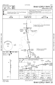
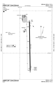
Runways:
| RWY identifier | QFU | Length (ft) | Width (ft) | Surface | LDA (ft) |
| 17 | 179° | 7000 | 100 | ASPH | |
| 35 | 359° | 7000 | 100 | ASPH |
Airport contact information
Address: Vernal United States
