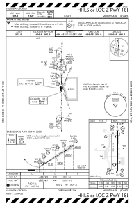
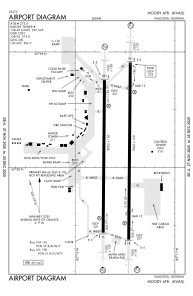


KVAD - Moody Afb
Located in Valdosta, United States
ICAO - VAD, IATA - VAD
Data provided by AirmateGeneral information
Coordinates: N30°58'7" W83°11'35"
Elevation is 233 feet MSL.
Magnetic variation is -03° East View others Airports in Georgia
Operational data
Special qualification required
Current time UTC:
Current local time:
Weather
METAR: KVAD 022255Z AUTO 12006KT 10SM CLR 30/17 A2991 RMK AO2 SLP129 T03010172 $
TAF: TAF AMD KVAD 022230Z 0222/0322 12006KT 9999 BKN060 QNH2990INS TEMPO 0223/0303 16015G25KT 8000 -TSRA BKN010CB BECMG 0311/0312 16006KT 9999 BKN010 QNH3000INS TEMPO 0312/0314 3200 BR BKN005 BECMG 0315/0316 16010G15KT 9999 SCT030 QNH2998INS TX31/0222Z TN20/0310Z
Communications frequencies: [VIEW]
Runways:
| RWY identifier | QFU | Length (ft) | Width (ft) | Surface | LDA (ft) |
| 18L | 180° | 9300 | 150 | CONC | |
| 36R | 0° | 9300 | 150 | CONC | |
| 18R | 180° | 8002 | 150 | OTHER | 8002 |
| 36L | 0° | 8002 | 150 | OTHER | 8002 |
Airport contact information
Address: Valdosta United States