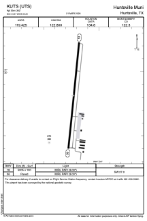


KUTS - Huntsville Muni
Located in Huntsville, United States
ICAO - UTS, IATA - HTV
Data provided by AirmateGeneral information
Coordinates: N30°44'49" W95°35'14"
Elevation is 362 feet MSL.
Magnetic variation is 06° East View others Airports in Texas
Operational data
Special qualification required
Current time UTC:
Current local time:
Weather
METAR: KUTS 011753Z AUTO 16009G20KT 10SM FEW055 28/22 A2989 RMK AO2 SLP117 T02830217 10289 20211 58012
TAF: KUTS 011726Z 0118/0218 15007KT P6SM BKN015 BKN025 FM012000 14010G18KT P6SM VCTS BKN025CB FM020300 13006KT P6SM VCTS OVC025CB FM020600 14009KT 4SM SHRA BR VCTS OVC007CB FM021200 06005KT 4SM -RA BR OVC007 PROB30 0212/0214 4SM -TSRA BKN007CB FM021600 14006KT P6SM OVC007
Communications frequencies: [VIEW]
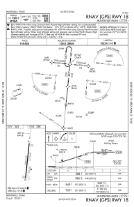
Runways:
| RWY identifier | QFU | Length (ft) | Width (ft) | Surface | LDA (ft) |
| 18 | 186° | 5005 | 100 | ASPH | |
| 36 | 6° | 5005 | 100 | ASPH |
Airport contact information
Address: Huntsville United States
