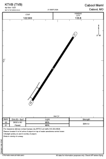


KTVB - Cabool Meml
Located in Cabool, United States
ICAO - TVB, IATA -
Data provided by AirmateGeneral information
Coordinates: N37°7'57" W92°5'2"
Elevation is 1220 feet MSL.
Magnetic variation is 03° East View others Airports in Missouri
Operational data
Special qualification required
Current time UTC:
Current local time:
Weather at : KUNO - West Plains Rgnl ( 32 km )
METAR: KUNO 071853Z AUTO 23008G19KT 190V270 10SM FEW049 SCT065 28/16 A2965 RMK AO2 PK WND 22028/1841 SLP024 T02830161
Communications frequencies: [VIEW]
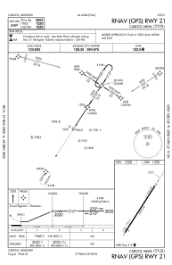
Runways:
| RWY identifier | QFU | Length (ft) | Width (ft) | Surface | LDA (ft) |
| 03 | 33° | 3002 | 60 | ASPH | |
| 21 | 213° | 3002 | 60 | ASPH |
Airport contact information
Address: Cabool United States