


KTRK - Truckee-Tahoe
Located in Truckee, United States
ICAO - TRK, IATA - TKF
Data provided by AirmateGeneral information
Coordinates: N39°19'12" W120°8'22"
Elevation is 5904 feet MSL.
Magnetic variation is 14° East View others Airports in California
Operational data
Special qualification required
Current time UTC:
Current local time:
Weather
METAR: KTRK 210048Z VRB03KT 10SM FEW095 21/01 A3008
TAF: KTRK 202320Z 2100/2124 34007KT P6SM SCT060 FM210300 VRB02KT P6SM SKC FM210900 00000KT P6SM VCFG SKC FM211500 VRB03KT P6SM SKC FM212000 35007KT P6SM FEW060
Communications frequencies: [VIEW]
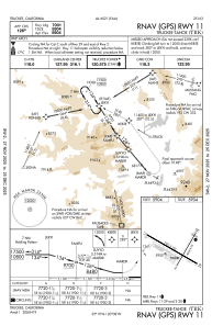
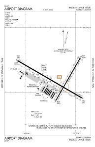
Runways:
| RWY identifier | QFU | Length (ft) | Width (ft) | Surface | LDA (ft) |
| 02 | 30° | 4654 | 75 | ASPH | |
| 20 | 210° | 4654 | 75 | ASPH | |
| 11 | 120° | 7001 | 100 | ASPH | |
| 29 | 300° | 7001 | 100 | ASPH |
Airport contact information
Address: Truckee United States

