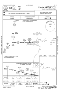
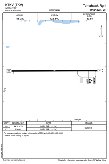


KTKV - Tomahawk Rgnl
Located in Tomahawk, United States
ICAO - TKV, IATA -
Data provided by AirmateGeneral information
Coordinates: N45°28'10" W89°48'18"
Elevation is 1486 feet MSL.
Magnetic variation is -02° East View others Airports in Wisconsin
Operational data
Special qualification required
Current time UTC:
Current local time:
Weather
METAR: KTKV 282055Z AUTO 06007KT 4SM SCT010 OVC014 06/05 A2995 RMK AO2 P0008 60009 T00610045 PWINO
Communications frequencies: [VIEW]
Runways:
| RWY identifier | QFU | Length (ft) | Width (ft) | Surface | LDA (ft) |
| 09 | 90° | 4401 | 75 | ASPH | |
| 27 | 270° | 4401 | 75 | ASPH |
Airport contact information
Address: Tomahawk United States
