


KTIF - Thomas County
Located in Thedford, United States
ICAO - TIF, IATA -
Data provided by AirmateGeneral information
Coordinates: N41°57'46" W100°34'13"
Elevation is 2925 feet MSL.
Magnetic variation is 08° East View others Airports in Nebraska
Operational data
Special qualification required
Current time UTC:
Current local time:
Weather
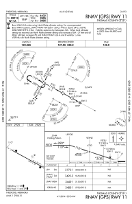
METAR: KTIF 292015Z AUTO 31010G17KT 10SM SCT075 SCT090 21/02 A2983 RMK AO2 T02070016
Communications frequencies: [VIEW]
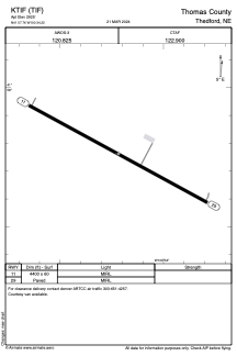
Runways:
| RWY identifier | QFU | Length (ft) | Width (ft) | Surface | LDA (ft) |
| 11 | 118° | 4400 | 60 | CONC | |
| 29 | 298° | 4400 | 60 | CONC |
Airport contact information
Address: Thedford United States