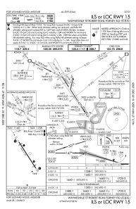
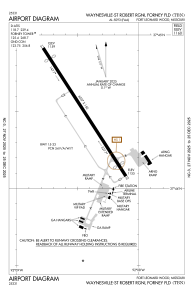


KTBN - Waynesville-St Robert Rgnl Forney Fld
Located in Fort Leonard Wood, United States
ICAO - TBN, IATA - TBN
Data provided by AirmateGeneral information
Coordinates: N37°44'30" W92°8'27"
Elevation is 1159 feet MSL.
Magnetic variation is 00° East View others Airports in Missouri
Operational data
Special qualification required
Current time UTC:
Current local time:
Weather
METAR: KTBN 070610Z AUTO 14012G18KT 10SM BKN026 BKN032 23/19 A2959 RMK AO2 SLP012
TAF: TAF KTBN 062100Z 0621/0803 19006KT 9999 BKN036 OVC050 QNH2977INS BECMG 0703/0705 15010G25KT 9999 RA SCT019 OVC027 QNH2970INS BECMG 0708/0710 18010G25KT 9999 +TSRA OVC018CB QNH2960INS BECMG 0709/0711 18010G25KT 9000 -SHRA BKN010 OVC018 QNH2958INS BECMG 0711/0713 20010G25KT 9000 -RA BKN018 OVC026 QNH2957INS BECMG 0717/0719 25010G25KT 9999 NSW SKC QNH2960INS BECMG 0723/0801 25009KT 9999 SKC QNH2957INS TX27/0720Z TN20/0711Z LAST NO AMDS AFT 0703 NEXT 0712
Communications frequencies: [VIEW]
Runways:
| RWY identifier | QFU | Length (ft) | Width (ft) | Surface | LDA (ft) |
| 15 | 147° | 6037 | 150 | ASPH | |
| 33 | 327° | 6037 | 150 | ASPH |
Airport contact information
Address: Fort Leonard Wood United States