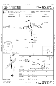
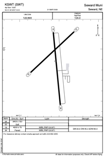


KSWT - Seward Muni
Located in Seward, United States
ICAO - SWT, IATA -
Data provided by AirmateGeneral information
Coordinates: N40°51'53" W97°6'33"
Elevation is 1505 feet MSL.
Magnetic variation is 06° East View others Airports in Nebraska
Operational data
Special qualification required
Current time UTC:
Current local time:
Weather at : KLNK - Lincoln ( 29 km )
METAR: KLNK 291854Z 26014KT 10SM CLR 19/08 A2989 RMK AO2 SLP119 T01940078
TAF: KLNK 291720Z 2918/3018 26012KT P6SM SKC FM292300 27008KT P6SM SKC FM301500 18015G23KT P6SM SCT250
Communications frequencies: [VIEW]
Runways:
| RWY identifier | QFU | Length (ft) | Width (ft) | Surface | LDA (ft) |
| 04 | 47° | 3400 | 150 | GRASS | |
| 22 | 227° | 3400 | 150 | GRASS | |
| 16 | 174° | 4200 | 75 | CONC | |
| 34 | 354° | 4200 | 75 | CONC |
Airport contact information
Address: Seward United States