


KSUD - Stroud Muni
Located in Stroud, United States
ICAO - SUD, IATA -
Data provided by AirmateGeneral information
Coordinates: N35°47'22" W96°39'20"
Elevation is 900 feet MSL.
Magnetic variation is 06° East View others Airports in Oklahoma
Operational data
Special qualification required
Current time UTC:
Current local time:
Weather at : KCQB - Chandler Rgnl ( 17 km )
METAR: KCQB 030355Z AUTO 29003KT 10SM -VCTSRA OVC020 19/19 A2986 RMK AO2 LTG DSNT ALQDS P0004 T01940190
Communications frequencies: [VIEW]
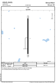
Runways:
| RWY identifier | QFU | Length (ft) | Width (ft) | Surface | LDA (ft) |
| 18 | 180° | 3000 | 60 | ASPH | |
| 36 | 360° | 3000 | 60 | ASPH |
Airport contact information
Address: Stroud United States