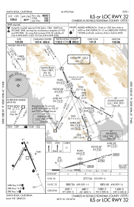
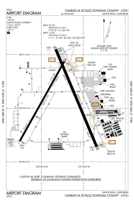


KSTS - Charles M Schulz - Sonoma County
Located in Santa Rosa, United States
ICAO - STS, IATA - STS
Data provided by AirmateGeneral information
Coordinates: N38°30'35" W122°48'46"
Elevation is 128 feet MSL.
Magnetic variation is 16° East View others Airports in California
Operational data
Special qualification required
Current time UTC:
Current local time:
Weather
METAR: KSTS 032053Z 17007KT 10SM CLR 25/08 A2989 RMK AO2 SLP114 T02500078 58015
TAF: KSTS 031738Z 0318/0418 33005KT P6SM SKC FM031900 31012KT P6SM BKN250 FM040500 25007KT P6SM VCSH SCT020 FM041000 20011KT 6SM -RA OVC009 FM041300 27012KT 6SM RA BR OVC015 FM041700 29006KT 6SM BR VCSH OVC025
Communications frequencies: [VIEW]
Runways:
| RWY identifier | QFU | Length (ft) | Width (ft) | Surface | LDA (ft) |
| 02 | 29° | 5202 | 100 | ASPH | 4802 |
| 20 | 209° | 5202 | 100 | ASPH | 5202 |
| 14 | 157° | 6000 | 150 | ASPH | 5880 |
| 32 | 337° | 6000 | 150 | ASPH | 6000 |
Airport contact information
Address: Santa Rosa United States
