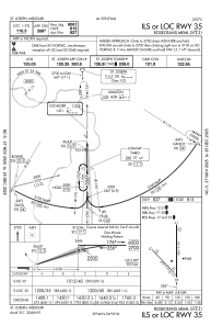
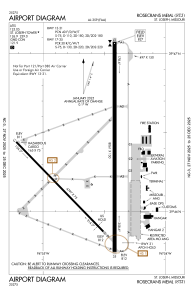


KSTJ - Rosecrans Meml
Located in St Joseph, United States
ICAO - STJ, IATA -
Data provided by AirmateGeneral information
Coordinates: N39°46'19" W94°54'35"
Elevation is 826 feet MSL.
Magnetic variation is 04° East View others Airports in Missouri
Operational data
Special qualification required
Current time UTC:
Current local time:
Weather
METAR: KSTJ 070445Z 31028G47KT 6SM VCTS -RA FEW022 BKN075 OVC095 18/16 A2959 RMK AO2 PK WND 30047/0445 LTG DSNT ALQDS TSE39 P0015 T01830156
TAF: KSTJ 062320Z 0700/0724 14012G22KT P6SM SCT025 BKN035 FM070230 22015G25KT 5SM -TSRA OVC035CB TEMPO 0703/0704 VRB30G40KT 2SM +TSRA OVC025CB FM070500 21012KT 5SM -TSRA OVC035CB FM070700 21006KT P6SM SCT040 OVC100 FM071000 VRB04KT 4SM BR SCT004 SCT250 FM071400 24009KT P6SM SCT250
Communications frequencies: [VIEW]
Runways:
| RWY identifier | QFU | Length (ft) | Width (ft) | Surface | LDA (ft) |
| 13 | 136° | 4797 | 75 | CONC | 4797 |
| 31 | 316° | 4797 | 75 | CONC | 4797 |
| 17 | 180° | 8061 | 150 | CONC | 8061 |
| 35 | 0° | 8061 | 150 | CONC | 8061 |
Airport contact information
Address: St Joseph United States