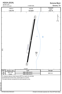


KSOA - Sonora Muni
Located in Sonora, United States
ICAO - SOA, IATA -
Data provided by AirmateGeneral information
Coordinates: N30°35'8" W100°38'55"
Elevation is 2139 feet MSL.
Magnetic variation is 08° East View others Airports in Texas
Operational data
Special qualification required
Current time UTC:
Current local time:
Weather
METAR: KSOA 012235Z AUTO 13006G12KT 9SM OVC016 24/21 A2978 RMK AO2
TAF: KSOA 012045Z 0121/0218 15012G18KT P6SM BKN025 FM020100 15007KT P6SM VCTS BKN030CB TEMPO 0202/0204 VRB25G35KT 3SM TSRA BKN030CB FM020400 14010KT P6SM BKN015 FM021000 17005KT P6SM SCT007 OVC012
Communications frequencies: [VIEW]
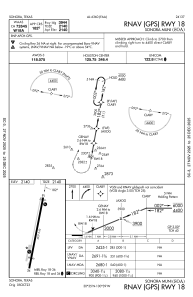
Runways:
| RWY identifier | QFU | Length (ft) | Width (ft) | Surface | LDA (ft) |
| 18 | 190° | 4037 | 60 | ASPH | |
| 36 | 10° | 4037 | 60 | ASPH |
Airport contact information
Address: Sonora United States