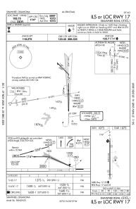
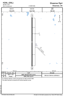


KSNL - Shawnee Rgnl
Located in Shawnee, United States
ICAO - SNL, IATA -
Data provided by AirmateGeneral information
Coordinates: N35°21'26" W96°56'34"
Elevation is 1073 feet MSL.
Magnetic variation is 06° East View others Airports in Oklahoma
Operational data
Special qualification required
Current time UTC:
Current local time:
Weather
METAR: KSNL 030455Z AUTO 00000KT 10SM VCTS SCT041 BKN050 BKN070 20/19 A2984 RMK AO2 LTG DSNT E SE AND NW T01960185
Communications frequencies: [VIEW]
Runways:
| RWY identifier | QFU | Length (ft) | Width (ft) | Surface | LDA (ft) |
| 17 | 180° | 5997 | 100 | ASPH | |
| 35 | 360° | 5997 | 100 | ASPH |
Airport contact information
Address: Shawnee United States