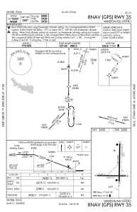


KSNK - Winston Fld
Located in Snyder, United States
ICAO - SNK, IATA -
Data provided by AirmateGeneral information
Coordinates: N32°41'36" W100°57'2"
Elevation is 2430 feet MSL.
Magnetic variation is 08° East View others Airports in Texas
Operational data
Special qualification required
Current time UTC:
Current local time:
Weather
METAR: KSNK 011935Z AUTO 15014G19KT 10SM SCT042 BKN050 29/17 A2977 RMK AO2 T02920173
Communications frequencies: [VIEW]
Runways:
| RWY identifier | QFU | Length (ft) | Width (ft) | Surface | LDA (ft) |
| 08 | 90° | 4200 | 75 | ASPH | |
| 26 | 270° | 4200 | 75 | ASPH | |
| 17 | 180° | 5599 | 100 | ASPH | |
| 35 | 0° | 5599 | 100 | ASPH |
Airport contact information
Address: Snyder United States