


KSLE - Mcnary Fld
Located in Salem, United States
ICAO - SLE, IATA - SLE
Data provided by AirmateGeneral information
Coordinates: N44°54'34" W123°0'9"
Elevation is 213 feet MSL.
Magnetic variation is 17° East View others Airports in Oregon
Operational data
Special qualification required
Current time UTC:
Current local time:
Weather
METAR: KSLE 030056Z 17005KT 10SM BKN032 BKN070 14/08 A3005 RMK AO2 RAB2357E09 SLP175 P0000 T01440083
TAF: KSLE 022332Z 0300/0324 18003KT P6SM BKN029 OVC035 FM031500 VRB04KT P6SM SCT025 OVC035 FM032200 19008KT 6SM -RA BR OVC025
Communications frequencies: [VIEW]
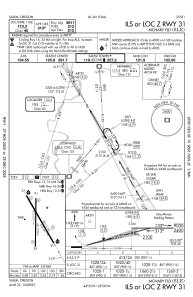
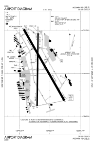
Runways:
| RWY identifier | QFU | Length (ft) | Width (ft) | Surface | LDA (ft) |
| 13 | 150° | 5811 | 150 | ASPH | 5811 |
| 31 | 330° | 5811 | 150 | ASPH | 5811 |
| 16 | 181° | 5146 | 100 | ASPH | 5145 |
| 34 | 1° | 5146 | 100 | ASPH | 5145 |
| H1 | 0° | 0 | 0 | UNK |
Airport contact information
Address: Salem United States
