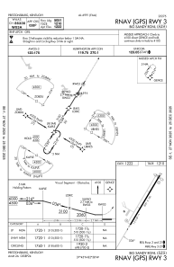
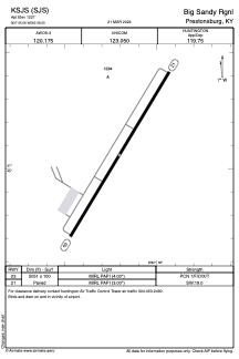


KSJS - Big Sandy Rgnl
Located in Prestonsburg, United States
ICAO - SJS, IATA -
Data provided by AirmateGeneral information
Coordinates: N37°45'4" W82°38'12"
Elevation is 1221 feet MSL.
Magnetic variation is -05° East View others Airports in Kentucky
Operational data
Special qualification required
Current time UTC:
Current local time:
Weather
METAR: KSJS 281955Z AUTO 12003KT 10SM SCT065 28/13 A3013 RMK AO2 T02840125
TAF: KSJS 281739Z 2818/2918 22007KT P6SM SKC FM291400 20007KT P6SM FEW250
Communications frequencies: [VIEW]
Runways:
| RWY identifier | QFU | Length (ft) | Width (ft) | Surface | LDA (ft) |
| 03 | 31° | 5000 | 100 | ASPH | |
| 21 | 211° | 5000 | 100 | ASPH |
Airport contact information
Address: Prestonsburg United States